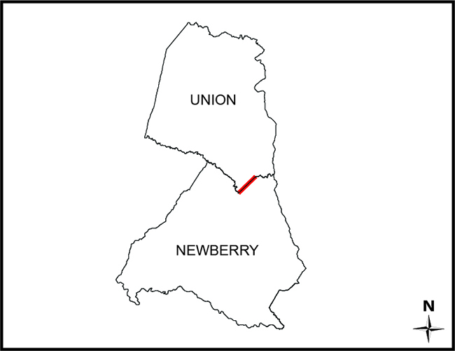
SECTION 4-3-410. NewbeRry County.
“…thence down Enoree River to Anderson's Ford; thence along the road to Hill's Ferry on Tyger River …”
SECTION 4-3-40. Union County.
“…the Enoree River, down to Avery’s Ford; thence by the road to Crenshaw’s Ford, on the Tyger River…”
- Certified Plat of Survey: Newberry County Slide D169, page 3; Union County Plat Book C110, page 308
- 1820/1825 Newberry District - Mills, Robert, and Marmaduke Coate. Newberry District, South Carolina. [1820] Map. Retrieved from the Library of Congress, <https://www.loc.gov/item/2007627689/>
- 1820/1825 Union District - Mills, Robert, and R. Thompson. Union District, South Carolina. [1825] Map. Retrieved from the Library of Congress, <https://www.loc.gov/item/2007627924/>.
- 1838 Clark Map - Map Containing 307 Acres in Newberry and Union Districts, Being a Part of the Land of George Clark; Surveyed December 1838.
- Blanche H. Cudd Tract (58) - Map Titled “Enoree Purchase Unit, Land of Blanche H. Cudd Number 58”; Surveyed by A.L. Glen & Party, Dated July 1934; Description Included.
- George S. Mower Estate Tract (150) - Map Titled “Enoree Purchase Unit, Land of George S. Mower Estate Number 150”; Surveyed by A.L. Glen & Party, Dated August 1934; Description Included.
- Govin Gordon Tract - Map of 43 Acres for Govin Gordon, Surveyed October 17, 1794.
- James Crenshaw Tract - Map of 697 Acres for James Crenshaw, Surveyed November 17, 1809.
- John L. Lyles Tract - Map of 183 Acres for John L. Lyles, by G.M. Girardeau, Surveyed January 23, 1878.
- John Valentine Tract - Map of 112 Acres for John Valentine, Surveyed August 11, 1807.
- Mrs. Carrie A. Shouse Tract (275) Map Titled “Enoree Purchase Unit, Land of Mrs. Carrie A. Shouse, etal Numbers 275 a, b”; Surveyed by A.L. Glen & Party, Last Revised April 18, 1936; Description Included.
- Nannie Belle Eison Tract (278) - Map Titled “-Sumter- Enoree District, Land of Nannie Belle Eison Tract No. 278”; Surveyed by A.L.G. & Party, Dated Nov. 1934; Description Included.
- Newberry Plat Book ‘AB’ page 51 Survey of “Lucy Frances A. Lorick Tract”, by Dan E. Collins, Last Revised May 15, 1969 and Recorded in Newberry County in Plat Book ‘AB’ page 51; Union County in Plat Book ‘14’, page 158.
- Newberry Plat Book ‘AL’ page 49 - Map of “M.E. Abrams Land”; Surveyed Dec. 13, 1939, by J.R. Crawford; Copied May 14, 1969 by Dan E. Collins and Recorded in Newberry County in Plat Book ‘AL’ page 49.
- Newberry Plat Book ‘AY’ page 129 - Survey For “Boise Cascade Timberlands, Roberts Tract” by Freeland & Associates; dated July 20, 1981 and Recorded in the Office of the Register of Deeds for Newberry County in Plat Book ‘AY’, page 129.
- Newberry Plat Book ‘H’ page 6 - Plat by E.O. Counts, dated January 20, 1934 of a Combination of 3 Plats, Surveyed in 1853, 1875, and 1899 and Recorded in Newberry County in Plat Book ‘H’ page 6.
- Newberry Plat Book ‘U’ page 75 - Survey of “That Part of Pettus W. Chicks Home Place, Lying on the South West Side of the State Road Between Tyger and Enoree Rivers”, by J.R. Renwick, dated November 29, 1883; Copied December 22, 1964 and Recorded in Newbe
- Phillip Auberry Tract - Map of 480 Acres for Phillip Auberry, Dated August 10, 1785.
- Samuel Awberry Tract - Map of 100 Acres for Samuel Awberry, Dated January 19, 1763.
- W.N. Glymph Tract (291) - Map Titled “-Sumter- Enoree District, Land of W.N. Glymph #291”; Surveyed by A.L. Glen & Party, Dated 1935-1938; Description Included.
Disclaimer
The Revenue and Fiscal Affairs Office is providing access to these materials for educational and research purposes and is not aware of any U.S. copyright protection (see Title 17 of the United States Code) or any other restrictions in the provided materials.
Note that the written permission of the copyright owners and/or other rights holders (such as publicity and/or privacy rights) is required for distribution, reproduction, or other use of protected items beyond that allowed by fair use or other statutory exemptions. Responsibility for making an independent legal assessment of an item and securing any necessary permissions ultimately rests with persons desiring to use the item.