SC Code of Law: (http://www.scstatehouse.gov/code/t04c003.php)
SECTION 4-3-90. Calhoun County.
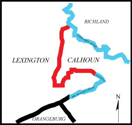
"Calhoun County is bounded as follows: beginning in Lexington County on the Congaree River at a point where the land line between land now or formerly owned by C. M. Cremaretie and land now or formerly owned by Vandy Spears strikes said river and running the land line between said lands (Said Cremaretie land is in and said Spears land is out of Calhoun County) crossing the State Road on this same land line, continuing straight line 125 chains to a pine on the Pine Plain Road, thence S. 21� 50' W. 16.50 chains to pine on same road; thence S. 10� W. 71 chains to a stake on land now or formerly owned by Nina Davis; thence S. 23� E. on said line (Said Davis land is out of and land now or formerly owned by Geiger is in Calhoun County) crossing the Savanay Hunt Creek (Land now or formerly owned by Crawley is out of Calhoun County) at 45 chains to a pine, total distance 103 chains, then S. 11� W. to a dead pine on Pine Plain Road, distance 3 miles, S. 2� E. with road 20 chains, same line 55 chains to Big Sandy Run near the south of Huckabass Mill, continuing to 1 mile, then S. 36.50� W. 35 chains to a pine near Pine Plain Road, S. 29.50� W. said road line, 23.50 chains, dead pine then S. 33� W. 53 chains to pine and stake on Rast land, then S. 9.50� W. 11 chains pine, S. 1� E. straight line to line of land now or formerly owned by Mrs. R. L. Baker, then with said line to a corner near Camp Ground Road, then a straight line to Orangeburg Road near Porterfield Mill, then a direct line to the head of Branham Branch and with said branch to Beaver Creek......"
SECTION 4-3-370.Lexington County.
"Lexington County is bounded on the northeast and east by Richland County; on the southeast by Orangeburg and Calhoun Counties, from which it is divided by Beaver Creek........."
- Certified Plat of Survey Signed by Brian Bonds PLS# 28582
- PDF Copy of the Public Presentation on Calhoun Lexington Boundary
- Preliminary Plat of Survey for the Calhoun Lexington County Boundary
- Old Sandy Run Road from Rts 21 & 176 to Lexington Co. Line. F.A.P. No S-578(i). DKT No 9.267. August 20, 1951.
- Pine Plain Road from S-31 to Swansea. SC State Highway Department. Lexington County. February 24, 1955
- Calhoun-Lexington Co. Route I-26 from Lexington Co Line to Route 21. September 25, 1958
- Pine Plain Road. SC State Highway Department. Lexington County. File 32.661. Project C.661. July 1,1975
- Pine Plain Road from road S-1475 (Stagecoach Rd) to Calhoun County Line. File 32.026886A. Project C-26886. February 27, 2007
- Calhoun Plats:Plat Book 2, pages 10, 11 and 12, with multiple plats on each page. Jno. C. Muller, Surveyor, December 1917.
- “…form and position of a proposed new County, to be called “CALHOUN”…From an 1869 map of Orangeburg townships and an 1885 map of Lexington County made by Paul B. Kyzer. Survey made by D. J. Rumff, L. G. Inabinet, S. R. Mellichamp and Wm. A. Mellichamp, Surveyor. No date.
- Surveyed 1910 by O. H. Bissell and W. H. Newell S. and C.E. Area 39.25 sq. miles.
- Scale: 1in:3000ft. From Survey by Hamby & Hamby Eng, Theod. C. Hamby, C.E. September 1907.
- Surveyed June 1907 by L. N. Bellinger, Surveyor and C.E. Fred H. Gramling, Surveyor and Frank W. Frederick, C.E.
- Calhoun plats from the Congaree to Pine Plain Road.Carolina Eastman Plat Lexington plat book 69-G, page 58 and 59, 1964, Plat book 11, page 585, DAK Americas LLC Deed Calhoun deed Book 260, pages 71 – 102, Wetlands Survey, Eastman Chemical Company. Calhoun Plat pb 10126, page 164.
- Calhoun Plats: Plat Book 10 page 268, Cabinet 1 page 5455, Plat Book 8 page 251, Plat 3531, Plat Book 10 page 402. Calhoun Deed: Deed Book 22, page 225 mentioning Porterfield Mill.
- Calhoun Plat cabinet 1 page 5065, Calhoun Plat cabinet 1 page 4957, Calhoun Plat 2054, Calhoun Plat book 11 page 866, Calhoun Plat 2041, Calhoun Plat cabinet 1 page 4496.
- Calhoun Plats along Northern Pine Plain Road.Calhoun Plat 999, Calhoun plat book P-12 page 62, Calhoun plat book P-12 page 63, Calhoun Plat 2431, Calhoun Plat cabinet 2 page 105.
- Calhoun Plats: Cabinet 1 page 4730, Plat Book 9 page 28, Plat Book 9 page 293, Plat Book 11 page 46, Cabinet 1 page 5405, Cabinet 1 page 5434, Plat 1756, Plat 821, Plat book 9 page 92, Plat Book 11 page 544, Plat 3462b, Cabinet 1 page 5834.
- Lexington Plats:Plat Book 19268 page 148, Plat Slide 241 page 9B, Plat Book 18923 page 267, Plat Slide 184 page 7, Plat Book 11728 page 112, Plat Book 16071 page 157, Plat Book 19542 page 155, Plat Book 19405 page 160, Plat Book 10688 page 7, Plat Book 16649 page 139, Plat Book 11728 page 112, Plat Book 13903 page 265.
- Lexington Plats:Plat Book 15980 page 95, Plat Book 228 page 167, Plat Book 16738 page 169, Plat Book 77-G page 191, Plat Book 3-G page 53, Plat Book 16277 page 109, Plat Book 105-G page 95, Plat Book 197 page 132B, Plat Book 17696 page 292, Plat Book 77-G page 189, Plat Book 66-G page 99.
Lexington Deeds: Deed Book 3-T page 626, Deed Book 21080 page 4700. - Lexington Plats:Plat Book 265 page 103A, Plat Book 225 page 489, Plat Book 225 page 490, Plat Book 39-G page 140.
- Lexington Plats:Plat Book 187-G page 448, Plat Book 237-G page 165A, Plat Book 200-G page 426, Plat Book 219-G page 8, Plat Slide 67 page 4, Plat Book 207-G page 666, Plat Book 14401 page 80, Plat Book 5-G page 105, Plat Book 10713 page 1.
- Lexington Plats:Plat Book 235 page 155A, Plat Book 10-G page 39, Plat Book 97 page 66, Plat Book 225 page 488, Plat Book 98-G page 201, Plat Book 14-G page 21, Plat Book 168-G page 68, Plat Book 194-G page 84, Plat Book 20924 page 4851, Plat Book 17894 page 300, Plat Book 237 page 92A, Plat Slide 987 page 5, Plat Book 18174 page 99, Plat Book 19012 page 320, Plat Book 90-G page 102, Plat Book 9872 page 146, Plat Slide 40 page 7, Plat Book 146-G page 291, Plat Book 10582 page 202.
- Lexington Plats: Plat Book 59-G page 290 once Cromartie Land, Plat Book 13904 page 296, Plat Book 21022 page 966, and an unrecorded Lexington plat.
- Dotted lines are survey by L. L. Low in 1914. Solid shows change and new survey by A. L. Lown June 27, 28, 1924.
Disclaimer
The Revenue and Fiscal Affairs Office is providing access to these materials for educational and research purposes and is not aware of any U.S. copyright protection (see Title 17 of the United States Code) or any other restrictions in the provided materials.
Note that the written permission of the copyright owners and/or other rights holders (such as publicity and/or privacy rights) is required for distribution, reproduction, or other use of protected items beyond that allowed by fair use or other statutory exemptions. Responsibility for making an independent legal assessment of an item and securing any necessary permissions ultimately rests with persons desiring to use the item.