SC Code of Law: (http://www.scstatehouse.gov/code/t04c003.php)
SECTION 4-3-240. Edgefield County
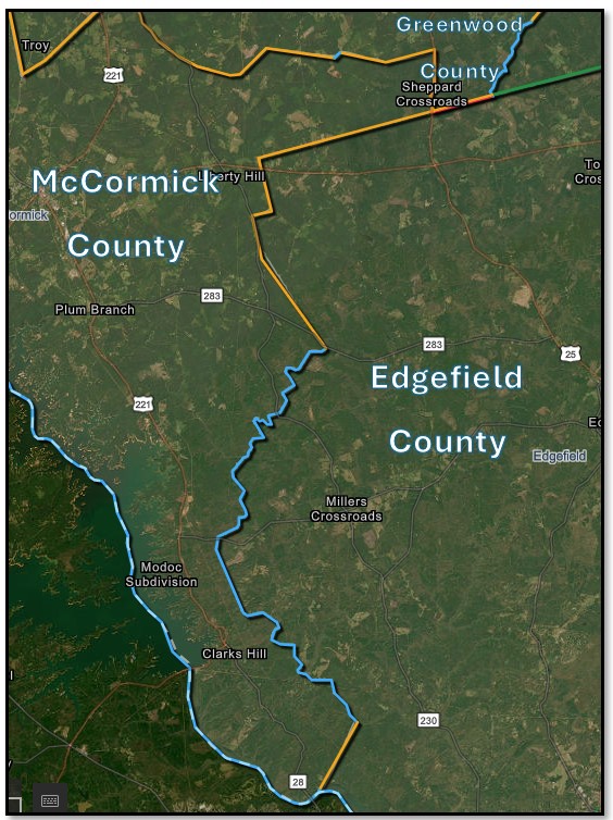
Edgefield County is bounded as follows: on the north and northeast by Greenwood and Saluda Counties; on the southeast by Aiken County; on the south and southwest by the Savannah River, which separates it from Georgia and McCormick County, which latter county is separated from Edgefield County by a line beginning on the Greenwood‑Edgefield County line more particularly described in the boundaries of McCormick County, and running in a westerly direction to a stake about 1/4 of a mile west of the old White place; thence in a straight line S. 13° E. 10,978 feet to a stake; thence S. 77° W. 3,750 feet to a stake; thence S. 13° E. 8,522 feet to a pine; thence S. 35° 45’ E. 20,400 feet to Cochran’s Bridge, on Turkey Creek; thence S. 26° 30’ E. 1,680 feet to a point where a branch crosses a public road; thence S. 59° 30’ W. 27,908 feet to the run of Big Stevens’ Creek; thence down the run of Big Stevens’ Creek to a stake; thence S. 50° W. 22,828 feet to the South Carolina‑Georgia line in the Savannah River, and in addition the following territory transferred from McCormick County by act of the General Assembly, approved February 9 1921, to wit: beginning on the McCormick and Edgefield County line at Moultrie’s Mill Branch on Turkey Creek; thence down the run of Turkey Creek to its intersection with Stephen’s Creek; thence down the run of Stephen’s Creek to the Edgefield and McCormick County line; thence to Edgefield and McCormick County line N. 59° 45’ E. 27,908 feet to a corner at the intersection of a public road with a branch of Beaver Creek; thence with the Edgefield and McCormick County line N. 26° 15’ W. 16,800 feet to the beginning, less the following territory transferred to McCormick County by act of the General Assembly, approved February 11 1921, to wit: all of that certain territory or portion of Edgefield County embraced within the following lines and boundaries, to wit: beginning at a cottonwood tree on the west bank of Stephen’s Creek; thence to Edgefield and McCormick County line and the South Carolina and Georgia State line of the Savannah River; thence the South Carolina and Georgia State line on the Savannah River to old Furry’s Ferry; thence a straight line N. 24° E. to a stake X 3 N. on the west bank of Stephen’s Creek to the beginning point.
SECTION 4-3-290. Greenwood County.
to its northwest corner on Mountain Creek; thence a straight line to the middle line of Shinburg Bridge on Cuffa Town Creek;
SECTION 4-3-400. McCormick County
; thence the said Greenwood‑Edgefield County line in a westerly direction to a stake about one quarter of a mile west of the old White place; thence a straight line S. 13° E. 10978 feet to a stake; thence a straight line S. 77° W. 3750 feet to a stake; thence a straight line S. 13° E. 8522 feet to a pine; thence a straight line S. 35° 45’ 20400 feet to Cochran Bridge on Turkey Creek; thence a straight line S. 26° 30’ E. 16800 feet to a point where a branch crosses a public road; thence a straight line S. 59° 10’ W. 27908 feet to the run of Big Stevens Creek; thence down the run of Big Stevens Creek to a stake; thence a straight line S. 50° W. 22828 feet to the South Carolina‑Georgia State line in the Savannah River; thence the said South Carolina‑Georgia State line in a northwesterly direction to the beginning point. The said county is hereby named McCormick, and the county seat thereof is hereby established in the town of McCormick, and in addition the following territory transferred from Edgefield County by act of the General Assembly, approved February 11 1921, to wit: beginning at a cottonwood tree on the west bank of Stevens Creek; thence the Edgefield and McCormick County line to the South Carolina and Georgia State line in the Savannah River; thence the South Carolina and Georgia State line in the Savannah River to old Furry’s Ferry; thence a straight line north twenty‑four degrees east to a stake X3N on the west bank of Stevens Creek; thence up the west bank of Stevens Creek to the beginning point, and less the following territory transferred to Edgefield County by act of the General Assembly, approved February 9 1921, to wit: beginning on the McCormick and Edgefield County line at Moultrie’s Mill Bridge on Turkey Creek; thence down the run of Turkey Creek to its intersection with Stevens Creek; thence down the run of Stevens Creek to the Edgefield and McCormick County line; thence the Edgefield and McCormick County line N. 59° 45’ E. 27908 feet to a corner at the intersection of a public road with a branch of Beaver Creek; thence the Edgefield and McCormick County line N. 26° 15’ W. 16800 feet to the beginning point.
- Public Presentation of the Re-establishment of the Edgefield-Greenwood-McCormick County Boundary
- Folder Containing .dbf .idx .prj .shp .shx Files
- Plat of survey certified 5/5/26
- CODE OF LAWS OF South Carolina 1976; Volume 1A; Chapter 3; Boundaries of Existing Counties; Sec 4-.-240 Edgefield County; Sec 4.-3-290 Greenwood County; Sec. 4-3-400 McCormick County; Sec. 4-3-470 Saluda County.
- McCormick, Georgia-South Carolina, surveyed in 1890, edition of July 1892, reprinted 1899; Athens, Georgia-South Carolina, surveyed in 1988; Clark Hill Lake, Georgia-South Carolina, 1980; Martinez, Georgia-South Carolina, surveyed 2020; Clark Hill, surveyed in 1918-1919, edition of 1920; Clark Hill, Georgia-South Carolina, surveyed 1941; Colliers, South Carolina, surveyed 2020; Limestone, South Carolina., surveyed 1965; Limestone, SC, surveyed 2020; Parksville, Georgia-South Carolina, surveyed 1964; Parksville, Georgia-South Carolina, surveyed 2020; Red Hill, South Carolina, surveyed 1964; Red Hill, South Carolina, surveyed, 2020; Winterseat, South Carolina, surveyed 2020.
- Map titled “Map of the Proposed County of Greenwood: by Theos. B. Lee; Surveyed August 1894.
- Notes of Survey for a proposed County of Greenwood, South Carolina; Surveyed and certified by Teos. B. Lee; August 11, 1894.
- Map titled “Map of Greenwood County South Carolina” by Wm. H. Yeldell and W. J. Kirk; surveyed 1898.
- Map titled “Edgefield District, South Carolina”; surveyed by Thos. Anderson, 1817; improved for Mills Atlas, 1825.
- Map of Edgefield County, S.C. Surveyed by Isaac Boles; dated 1871.
- Map of Saluda County by Wm. H. Yeldell and W. A. Crouch; Dated Feb 7, 1896.
- Map of Proposed Calhoun County (later McCormick) by Yeldell and Britt, dated 1904.
- Map of the proposed Annexation of part of Edgefield County to Mc Cormick County by Teod. C. Hamby, C. W. Wannamaker and William Weston; dated Oct. 1920.
- Map of the proposed annexation of part of McCormick County to Edgefield County by Theod. C. Hamby; C. W. Wannamaker and William Weston; dated Oct. 1920.
- Map titled Long Cane Purchase Unit land of Bank of Greenwood Number 24”; surveyed by S. E. Puckette & Party; dated July 1934; also, the “Description of the Boundary of the Bank of Greenwood Tract (24)”.
- Map Titled “-Plat- Lands of Mrs. Callie Self Coker” by Thos. C. Anderson; dated June 19, 1948; Greenwood County MB. 23 page 175; Greenwood Count MB 35 Page 28; Greenwood County MB 9906 page 5062; Edgefield County MB 24 page 115; McCormick County Registrar of Deeds, Mortgage Book. 9 page 8.
- Map of 1560 acres for James Sheppard surveyed January 11, 1846.
- United States Forest Service field sheets, surveyed 1933 – 1936; revised 1940.
- South Carolina State Highway Department plan and profile of proposed state highway; F. A. Project No 55-B-Reop. Contract No. 2; Route No. U.S. 25; Dated 11-13-1928.
- Map titled: “Long Cane Purchase Unit Land of M. G. & L. L. Dorn, Inc. Number 21-e”; surveyed by S. E. Puckette & Party; dated September 1934: Also the Description of the Boundary of the M. G. & J. J. Dorn, INC Tract (21-e):.
- Mat titled “Long Cane Purchase Unit Land of J. P. Lewis Number 311” ; surveyed by S. E. Puckette & Party; dated September 1934 & January 1935; also, the “Description of the J. P. Lewis Tract (311)”.
- Map titled “Carland, Inc. Tract No. EDG. 1-1” by E. S. Ethridge; Dated 11-30-1967; McCormick County Registrar of Deeds, Mortgage Book 2 page 154; Edgefield County Judgement Roll 18864.
- Map of Tract No. 5 of Mrs. E. L . Hollingsworth Home Tract by A. K. Britt; dated November 25, 1942; McCormick County Registrar of Deeds Mortgage Book 1, page 193.
- South Carolina State Highway Department plan and profile of proposed state highway; McCormick County; Docket No. 33.259; Road S-138; Dated 07-01-1951.
- South Carolina State Highway Department plan and profile of proposed state highway; File: 33.339; Proj: BRZ-2033(2); Road S-138; dated 08-18-1983.
- Map titled “Sumter National Forest (Long Cane Division) M. G. & J. J. Dorn Inc. Tract (21j)”; also, the description of Tract #21j,
- Map titled “ Long Cane Purchase Unit Land of J. H. Bouknight Number 324”; surveyed by S. E. Puckette & Party; dated August 1934; also, the “Description of the Boundary of the J. H. Bouknight Tract #324”.
- Map titled “ W. A. Reynolds Estate Tract (395): by United States Forestry Service; dated 03-28-1940; also, the “Description of the W. A. Reynolds Estate Tract (395)”/
- Map by J. M. Bussey; dated June 22, 1933; revised July 22, 1967; McCormick County Registrar of Deeds, Mortgage Book 5 page 240.
- Map titled “Boundary Survey for tracts 1 & 3 Mildred G. Myers and Claude J. Myers tract 2 – Thel H. King, Alice H. Nichols & Kay Floyd” by Todd Surveys Inc.; dated November 23, 1998; McCormick County Registrar of Deeds; Mortgage Book 20 page 22.
- South Carolina State Highway Department plan and profile of proposed state highway; Docket No. 19.224; Route No 283; dated 01-07-1942.
- South Carolina State Highway Department plan and profile of proposed state highway; Federal Aid Project No. S132(1) Parts 2 & 3; Docket No. 33.224; State Route No. 283; Dated 02-18-1946.
- Map titled “Map of Washington S. D. No 25” by J. M. Bussoy; dated May 19, 1924; McCorrmick County Registrar of Deeds Mortgage Book 2 page 15.
- Map titled “Map of Consolidated High School District No. 1 of McCormick County So. Car.” By J. M. Bussoy; dated April 17, 1925.
- Map titled “Sumter National Forest (Long Cane District) Ellen McKie Wimberlee et al Tract (238)”; 1934-1938; also, the “Description of the Boundary of the Ellen McKie Wimberlee et al Tract (238)”.
- Map of the 919 acres for John Fury surveyed December 8, 1812.
- Map of the 2606 acres for Joseph Crafton surveyed March 21, 1833.
Disclaimer
The Revenue and Fiscal Affairs Office is providing access to these materials for educational and research purposes and is not aware of any U.S. copyright protection (see Title 17 of the United States Code) or any other restrictions in the provided materials.
Note that the written permission of the copyright owners and/or other rights holders (such as publicity and/or privacy rights) is required for distribution, reproduction, or other use of protected items beyond that allowed by fair use or other statutory exemptions. Responsibility for making an independent legal assessment of an item and securing any necessary permissions ultimately rests with persons desiring to use the item.