SC Code of Law: (http://www.scstatehouse.gov/code/t04c003.php)
SECTION 4-3-240. Edgefield County.
Edgefield County is bounded as follows: on the north and northeast by Greenwood and Saluda Counties;…
SECTION 4-3-470. Saluda County.
…thence by the Long Cane road to Matt Mathis' crossroads; thence a straight line to Owdom's Postoffice; thence a straight line to Little Red Hill schoolhouse near Dr. Landrum's old place; thence a straight line to a point on the northwestern line of Pine Grove township, one mile north of Double Bridges;
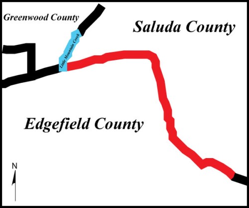
- Public presentation of the Mutual Boundary of Edgefield and Saluda County
- Certified Plat of Survey signed by Jacob Braxton PLS# 43366 dated 6/23/2025
- Detail showing Mathis residence at crossroads of Long Cane and Old Chappell Ferry roads.Surveyed by Isaac Boles. 1871.
- Map, not an actual plat, giving boundary line inflection points and locating the new county seat.Submitted by Alvin Etheredge, chairman, and other Boundary Commissioners, February 7, 1896.
- General Highway and Transportation Map Edgefield County South Carolina. Compiled from controlled aerial photographs and state-wide highway planning survey, rural road inventory.South Carolina State Highway Department.
- South Carolina State Highway Department Plan and Profile of Proposed State Highway. Docket Numbers 19.235 Pts. 1 & 2 and 41.240. Rd 21 (Rt. 231); Edgefield-Saluda Counties From Road 59 to Route 19. 1948.South Carolina State Highway Department.
- South Carolina State Highway Department Plan and Profile of Proposed State Highway. Docket Numbers 19.235 Pts. 1 & 2 and 41.240. Rd 21 (Rt. 231); Edgefield-Saluda Counties From Road 59 to Route 19. 1948.South Carolina State Highway Department.
- South Carolina State Highway Department Final Construction Plans. Docket Number 19.235 Pts. 1. Route No 231, Road 21; From Road 59 to Saluda County Line. 1949.South Carolina State Highway Department
- South Carolina State Highway Department Plan and Profile of Proposed State Highway. DKT. No 41.335; F.A.P. No. F-258(9); Saluda County. S.C. Rt. 21 From Rd. 37 to Edgefield Co. Line. 1964.South Carolina State Highway Department.
- South Carolina State Highway Department Plan and Profile of Proposed State Highway. Final Construction Plans. DKT. No 41.335; F.A.P. No. F-258(9); Saluda County. Route No. 121. 1966.South Carolina State Highway Department.
- Plat prepared for Marion C. Bledsoe, Edgefield County, on Long Cane Road and Ridge Road and Weaver Road, showing old roadbed. Surveyed by Dennis G Johns, PLS # 8102, January 22, 1993.
- Plat prepared for Holmes Timber Company, INC., Edgefield County, on Long Cane Road showing old roadbed/ approx. county line. Surveyed by Ronald Lee Burton, PLS # 15509, December 11, 2007.
- Plat prepared for Holmes Timber Company, INC., Edgefield County, on Long Cane Road and Simpkins Road showing old roadbed. Surveyed by Ronald Lee Burton, PLS # 15509, December 11, 2007.
- Plat prepared for Terry J. Quarles, Edgefield County, on Glover Circle, Old Long Cane Road.Surveyed by George S. Todd, PLS # 7409, December 27, 2017.
- Plat prepared for Dr. John Landrum, Edgefield County, showing estate of Dr. John Landrum between Loop de Loops Rd and Ephriam’s Branch. Surveyed by A. R. Abel, November 17, 1853.
- Plat showing school districts #8 N. Elmwood, #9 S. Elmwood, #35 Long Cane and #30 Meeting Street, details include Long Cane Rd and Mathis Crossroads. Surveyed by S.M. Smith, June 16, 1924.
- Plat prepared for J.W. Adams, Edgefield County, showing Owdom’s Land. Surveyed by H.E. Jenger, January 29, 1934.
- Plat prepared for Ronald C. Courtney, Edgefield County, on Long Cane Road showing old roadbed. Surveyed by George S. Todd, PLS # 7409, March 5, 2004.
- Plat prepared for Lonnie Jones and Amelia Jones, Edgefield County, on Simpkins Road and Old Long Cane Road showing old roadbed. Surveyed by George S. Todd, PLS # 7409, April 26, 2004.
- Plat prepared for Freda Glover, Glover Circle, Old Long Cane Road, Edgefield County.Surveyed by George S. Todd, PLS # 7409, July 24, 2014.
- Historic county tax map, aerial imagery with parcels hand drawn on top, parcel labeled as Little Red Hill Place, found at Saluda County Courthouse.
- Townships in Edgefield County as established by Isaac Boles, ESQ., County Surveyor, by order of the County Commissioners of Edgefield County.
- Connor and Lisa Walker present a copy of an 112-year-old plat of Saluda County to Saluda County Historical Society representatives...Saluda Standard Sentinel. Vol. 108 No. 9. February 28, 2002.
- "The commissioners as the corporate authorities of Saluda County had power to organize, to elect and to remove their own necessary officers by a majority vote."Inventory of the County Archives of South Carolina: No. 41, Saluda County. South Carolina Historical Records Survey Project. Division of Professional and Service Projects, Works Projects Administration. University of South Carolina, 1940. pages 33 and 34.
- Deed of property to current parcel TMS 012-00-00-001 referencing parcel as "The Little Red Hill Place" recorded in the Saluda County Clerk of Courts Offices, July 6th, 1999 at Deed Book 490 Page 248.
- December 7, 1939 aerial photography. Little Red Hill School environs.South Carolina Forestry Commission.
- February 23, 1941, aerial photography. Little Red Hill School environs.South Carolina Forestry Commission.
- February 23, 1941 aerial photography, Owdom’s Post Office site.South Carolina Forestry Commission.
- Announcing petition for survey of proposed Saluda County.Edgefield Advertiser, October 10, 1894, Page 3.
- February 7, 1962. Owdom’s Post Office site.United States Geodetic Survey.
- Owdoms Quad. Edition of 1964. Photorevised 1982.United States Geological Survey.
- Saluda South Quad. Edition of 1964. Photorevised 1982.United States Geological Survey.
Disclaimer
The Revenue and Fiscal Affairs Office is providing access to these materials for educational and research purposes and is not aware of any U.S. copyright protection (see Title 17 of the United States Code) or any other restrictions in the provided materials.
Note that the written permission of the copyright owners and/or other rights holders (such as publicity and/or privacy rights) is required for distribution, reproduction, or other use of protected items beyond that allowed by fair use or other statutory exemptions. Responsibility for making an independent legal assessment of an item and securing any necessary permissions ultimately rests with persons desiring to use the item.