SC Code of Law: (http://www.scstatehouse.gov/code/t04c003.php)
SECTION 4-3-400. McCormick County
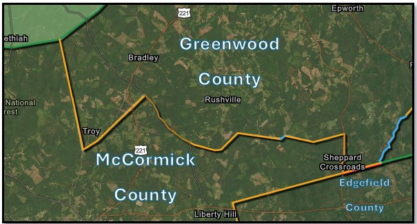
“…to a point on the Greenwood‑Abbeville County line near Jordan’s Mill; thence the said Greenwood‑Abbeville County line, in a southerly direction to its intersection with the C. & W. C. Railway, about one mile south of Troy; thence a straight line N. 58° E. 5000 feet to a stake, south of the incorporated limits of Troy; thence a straight line N. 46° E. 19659 feet to a stake on the Abbeville‑Edgefield public road; thence the said Abbeville‑Edgefield public road in a southerly direction to a road opposite the place now or formerly owned by Jabe Stone; thence N. 44° 30’ E. 7200 feet to a stake; thence a straight line S. 83° E. 13361 feet to a stake near or at Callison’s old mill on Cuffytown Creek; thence up the run of said creek to the Callison‑Kirksey township line; thence the said township line in an easterly direction to the Martintown road; thence the said Martintown road in a southeasterly direction to the Greenwood‑Edgefield County line..."
SECTION 4-3-290. Greenwood County.
Greenwood County is bounded as follows: beginning at the middle line of Saluda River at the northeast corner of Saluda County, thence along the line of Saluda County to its northwest corner on Mountain Creek; thence a straight line to the middle line of Shinburg Bridge on Cuffa Town Creek; thence down the middle line of Cuffa Town Creek to its junction with Hard Labor Creek; thence down the middle of Stevens' Creek to the mouth of Rocky Creek; thence up the middle line of Rocky Creek to the Abbeville and Edgefield County line; thence N. 33° W. to milepost on public road leading from Troy to McCormick near George Lebert's residence; thence N. 13° W. to a corner post 150 feet south of Jordan's old mill on Long Cane Creek;
- Preliminary Plat of Survey (pending certification)
- Text of Edgefield Advertiser article of August 4, 1870, describing boundaries of all Edgefield township boundaries at that time.
- Text of Edgefield Advertiser article of August 4, 1870, describing boundaries of all Edgefield township boundaries at that time.
- Map titled “boundary survey for short hills farm” by John h. Welborn & co.; last revised Jan. 13, 1995, Greenwood County mb. 102 pg. 134.
- Map titled “DeLoach tract Carland inc. Tract no. McC 2-20” by j. Hearst Coleman co., inc; dated 09-21-1967; McCormick County mb. 7 pg. 22.
- Map titled “long cane purchase unit land of d.p. Washburn, et al number 99-a”; surveyed by s.e. Puckette & party; dated February 1936; also, the “description of the boundary of the d.p. Washburn et al tract (99-a)”.
- Map titled “long cane purchase unit land of estate of joe lake number 90”; surveyed by S.E. Puckette & party; dated march, 1935; also, the description of the boundary of the estate of Joe Lake tract (90)’.
- Map titled “long cane purchase unit land of federal land bank of Columbia number 220-zs”; surveyed by S.E. Puckette & party: dated march 1935; also, the description of the boundary of the federal land bank of Columbia (220-z)
- Map titled “long cane purchase unit land of I.B. Stockman numbers 218 & 218-a”; surveyed by S.E. Pucketee & party; dated April, 1935; also, the description of the boundary of the I.B. Stockman tract(218)
- Map titled “long cane purchase unit lands of federal land bank of Columbia number 220-r”; surveyed by s.e. Puckette & party; dated march 1935; also, the description of the boundary of the federal land bank of Columbia tract (220-r)”.
- Map of a portion of Abbeville County, state of South Carolina, proposed to be annexed to greenwood county by C.J. Decamps and J.B. Marshall jr.; dated October 31, 1910
- Map titled ‘Sylvania” by E.S. Etheridge; Last revised 08-25-1962 Greenwood County MB. 9906 PG. 5035.
- titled “Boundary survey for Frank J. Wideman III & Ann Cheshire Wideman” by John H Welborn; Dated NOV. 21, Map 1994; Greenwood County MB. 93 PG. 130.
- Map titled “Farris c. Parker tr. #160”; dated 12-18-1970; also, the “surveyor’s report of the Farris c. Parker tract no. 160”
- Map titled “Long cane purchase unit land of estate of W.K. Bradley number 73-c”; Surveyed by S.E. Puckette & party; Dated February 1935; Also, the “description of the boundary of the estate of W.K. Bradley tract (73-c)’; Greenwood County MB. 9902 PG. 1851
- Map titled “long cane purchase unit land of s.c. Deal, et al number 78”; surveyed by s.e. Puckette & party; surveyed September 1934; also, the description of the boundary of the s.c. Deal, et al tract (78)”.
- Map titled “Long cane purchase unit land of the estate of W.K. Bradley number 73-d”; Surveyed by S.E. Puckette & party; Dated February, 1935; Also the “Description of the boundary estate of W.K. Bradley tract (73-d)”; Greenwood County MB. 9902 PG. 1661
- Map titled “map of property of international paper company Moseley tract”; surveyed by r.p. McMeekin; dated July 1955; greenwood county mb. 55 pg. 131; McCormick County mb. 14 pg. 19
- Map titled “Plat and sub-division of land lying in the county of greenwood, S.C. Known as geo. E. Dorn home place”; dated June 1920
- Map titled “Plat home place of estate rev. R.F. Bradley” by Thos. C. Anderson; Surveyed Sep. 2, 1933; Revised Oct. 13, 1939, Greenwood County MB. 9901 Pg. 2222.
- Map of a portion of Abbeville County, state of South Carolina, proposed to be annexed to greenwood county by C.J. Decamps and J.B. Marshall jr.; dated October 31, 1910
- Map titled “re-establishment of the Abbeville County and McCormick County boundary from the savannah river east to greenwood county” be CESI; dated 12-17-2024; job no.:220640.000; Abbeville County mb. 86 pg. 103: McCormick County mb.21 pf. 142.
- Map titled” map of property of international paper company Clark tract”; surveyed by s.m. Gladstone; dated Feb. 1951; greenwood county mb. 55 pg. 141; McCormick County mb. 14 pg. 21.
- Map titled “plat made at the request of Richard a. Green” by Heanor Incorporated; dated February 4, 2002; Greenwood County mb. 116 pg. 121.
- Map titled “plat of property surveyed for Catawba timber co. Wright tract 1282 (par. 4)” by J.R. McClure; dated June 4, 1969 McCormick County mb. 2 pg. 124.
- Map titled “plat of tract owned by Rainsford-Yarborough Forest products”; dated Feb. 1958; McCormick County mb. 4 pg. 125.
- Map titled “plat prepared for Holmes timber co inc” by George S Todd; dated may 23 1990; greenwood county mb. 59 pg. 127.
- Map titled “plat property belonging to Harrison trust” by Paul C. Wash; dated 01-28-1982; Greenwood County mb. 37. Pg. 142.
- Map of tract no.5 of mrs. E.l. Hollingsworth home tract by A.K. Britt; dated Nov. 25, 1942; McCormick County mb. 1 pg. 193
- Highway plans; McCormick county; docket no. 33.259; road s-138; dated 07-10-1951
- South Carolina state highway department plan and profile of proposed state highway; file: 33.399; proj.: brz-2033(2); road s-138; dated 08-18-1983
- Map titled “-plat- “lands of Mrs. Callie self coker by thos. C. Anderson; dated june 19, 1948; greenwood county mb. 9906 pg. 5062; Edgefield County mb. 24 pg. 115; McCormick County mb.9 pg. 8.
- South Carolina state highway department plan and profile of proposed state highway; F.A. Project no. 55-b-reop. Contract no 2; route no. U.s. 25; dated 11-13-1928
- Notes of survey for a proposed county of greenwood, South Carolina; surveyed and certified by teos. B. Lee; august 11, 1894.
- Map of Calhoun county south Carolina by Yeldell and britt dated 1904
- Abbeville, S.C. Sheet, Surveyed 1889-90, Edition of July 1892, Reprinted 1943; Limestone, S.C. Sheet, Surveyed 1962, 1965. Printed 1965;
Clark Hill Lake Georgia – South Carolina, Compiled from USGS Maps dated 1954-1972, Revised 1972, Edition of 1980;
Bradley Quadrangle South Carolina, Surveyed 1939-1940, 1947-1948, Edition of 1950;
Limestone, SC Sheet, Surveyed 1994, 2017-2019. Edition of 2020;
Bradley SC Sheet, Surveyed 2016-2023. Edition of 2024;
McCormick, S.C. Sheet, Surveyed 1962, 1964, Edition of 1964;
McCormick Sheet Georgia – South Carolina, Surveyed 1890, Edition of July 1892, Reprinted Nov. 1899;
Verdery Quadrangle South Carolina, Surveyed 1994, 2013-2020. Edition of 2020;
Winterseat Quadrangle South Carolina, Surveyed 1962, 1965, Edition of 1965.
McCormick Quadrangle South Carolina, Surveyed 1994, 2013-2020, Edition of 2020;
Verdery Quadrangle South Carolina, Surveyed 1939, 1947-1948, Edition of 1948;
Winterseat Quadrangle South Carolina, Surveyed 2014 - 2020, Edition of 2020.
- Map titled “map of the proposed county of greenwood: by Theos. B. Lee; surveyed august 1894.
- Map titled “map of Greenwood County South Carolina” by WM. H. Yeldell and w. J. Kirk; surveyed 1898.
- 1894 topographical map of Abbeville co. South Carolina by w.p. Bullock and p.l. Grier
- CODE OF LAWS OF South Carolina 1976; Volume 1A; Chapter 3; Boundaries of Existing Counties; Sec 4-.-240 Edgefield County; Sec 4.-3-290 Greenwood County; Sec. 4-3-400 McCormick County; Sec. 4-3-470 Saluda County.
- Map titled “plat showing home place of Mr. James a. Callison” by thos. C. Anderson; surveyed Nov. 8, 1905, and mar. 15, 1922.
- Plat showing part of W R Bowen property; dated Aug. 25, 1950; Greenwood County mb. 5 pg. 115.
- Map titled “plat showing the land of miss Elizabeth youngblood” by Thos. C. Anderson; dated oct. 30, 1934; greenwood county mb. 9904 pg. 24.
- Plat surveyed at the request of Capt. E.H. Youngblood by W.H. Yeldell; surveyed oct. 20, 1896; greenwood county mb. 23 pg. 122; McCormick County mb. 2 pg. 190.
- South Carolina state highway department plan and profile of proposed state highway; F.A.P. No F.H. 35-c; docket no 33.278; McCormick County Road no 171; dated 07-02-1953
- South Carolina state highway department plan and profile of proposed state highway; file no. 24.388; S.P. No. C-388; dated 02-12-1965.
- Map titled “southland timber Corp Timmons tract” by e s Ethridge; dated 12-31-1959; greenwood county mb. 9904 pg. 127.
- Plat showing part of W R Bowen property; dated Aug. 25, 1950; Greenwood County mb. 5 pg. 115.
- State of South Carolina state highway department plan and profile of proposed state highway; U.S. public works project No. H.R.H 125 and N.R.M. 125 (1935); Route No. 10; Dated 08-09-1933.
Disclaimer
The Revenue and Fiscal Affairs Office is providing access to these materials for educational and research purposes and is not aware of any U.S. copyright protection (see Title 17 of the United States Code) or any other restrictions in the provided materials.
Note that the written permission of the copyright owners and/or other rights holders (such as publicity and/or privacy rights) is required for distribution, reproduction, or other use of protected items beyond that allowed by fair use or other statutory exemptions. Responsibility for making an independent legal assessment of an item and securing any necessary permissions ultimately rests with persons desiring to use the item.