SC Code of Law: (http://www.scstatehouse.gov/code/t04c003.php)
SECTION 4-3-10. Abbeville County.
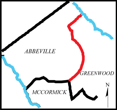
“Abbeville County is bounded as follows: … on the northeast by Laurens County, from which it is separated by the Saluda River, and by Greenwood County; and on the southeast by McCormick County.”
SECTION 4-3-290. Greenwood County.
“Greenwood County is bounded as follows: ... up the middle line of Rocky Creek to the Abbeville and Edgefield County line; thence N. 33 W. to milepost on public road leading from Troy to McCormick near George Lebert's residence; thence N. 13 W. to a corner post 150 feet south of Jordan's old mill on Long Cane Creek; thence N. 50 E. 2 3/4 miles; thence N. 42 E. 2 miles; thence N. 27 50' E. 2 miles; thence N. 13 20' E. 2 miles; thence N. 1 W. 2 miles; thence N. 15 10' W. 2 miles; thence N. 29 20' W. 2 miles; thence N. 43 35' W. 2 miles; thence N. 57 45' W. 1 1/5 miles, to post 400 feet north of Douglas' Mill Bridge on Long Cane Creek; thence N. 7 W. to division line between Long Cane and Cokesbury township; thence up said division line to its crossing of Long Cane Creek; thence up the middle line of Long Cane Creek to its crossing of the division line between Donald's and Cokesbury townships; thence along said Cokesbury and Donald's township division line to the middle line of Saluda River; ...”
- Plat of Survey Certified 11/21/2024 by R. Andrew Pletcher PLS# 22760
- Draft report on the survey of the Abbeville Greenwood County Boundary
- By Thomas B. Lee, C.E. Dated August 11, 1894.
- By W. P. Bullock and P. L. Grier for Abbeville County Commisstion, R. H. Armstrong, Chairman. Recorded in Library of Congress, Jan. 2, 1895.
- Map of a portion of Abbeville County, State of South Carolina, proposed to be annexed to Greenwood County, Surveyed October 1910 by C. J. DeCamps and J. B. Marshall by authority of the Board of Commissioners, George T. Magill Chairman.
- Map of Donalds School District (No. 39) containing 12.44 square miles. Surveyed by William L. Mitchell; dated May 16, 1913; revised August 7, 1924.
- Boundary survey of 87.922 acre tract in Greenwood and Abbeville counties for R. E. McDonald Estate by John. H. Welborn; dated November 7, 2005.
- Plat showing subdivision of Estate of Joseph L. and Tallulah H. Pressley situated in Greenwood and Abbeville Counties, SC. Total area 954 acres exclusive of church lot. Surveyed February 21 – 24, 1924 by Thomas C. Anderson, C.E.
- Plat of the William Klugh Estate situated about 7 miles west from Greenwood, SC on Greenwood-Abbeville county line. Surveyed and subdivided by Thomas C. Anderson, surveyor on June 14, 1928 at request of Mr. W. H. Nicholson, attorney. 1928
- Plat of 152.03 acres in Abbeville and Greenwood counties for Russell K. Wood and Tracy J. Wood by Barry K. Dunn, Sr. on March 9, 2016.
- Deed of sale with meets and bounds for 610.25 acre tract of land described as plat of Tract No. 4 found in Greenwood Plat Book 82 page 496. Deed dated September 19, 1949.
- Map of Troy School District containing 13.75 square miles. Survey completed for County Superintendent of Education. T. E. Dorn by J. F. Harling. October 12, 1922.
- Plat of 198 acres, marked No. 2, represents a portion of the real estate of James. H. Nickles. Partly surveyed and partly copied from surveys of Q. A. McCord, lying near Long Cane Creek in Abbeville County, SC. Surveyed by William Kirk. 1896.
- Map of Tract No. 4 of the Estate of Z. Haddan by W. L. Mitchell, dated August 13, 1900.
- Plat showing tract of land surveyed and subdivided for Ivan E. and W. Howard Corley. Located as shown approximately four miles west of City of Greenwood. Surveyed by Lucian D. Adams SR.-L.S. 1975
- Plat of 35 acres situated in Greenwood County near Abbeville County line being a part of the Estate of George W. Adams, deceased. Surveyed by Thomas C. Anderson. 1949.
- Plat of 151 acres, Tract 7 of Mrs. H. C. Dunn property. Survey completed by William L. Mitchell, C.E, September 1914.
- Plat of 78.12 acres, Tract 3 of Mrs. H. C. Dunn property. Survey completed by William L. Mitchell, C.E, September 1914.
- Plat of 61 acres, Tracts 5 & 6 of Mrs. H. C. Dunn property. Survey completed by William L. Mitchell, C.E, September 1914.
- Plat showing two tracts of land situated on Greenwood-Abbeville county line, state of S. Carolina. Total area 420.50 acres. Compiled from former surveys by Thomas C. Anderson, Surveyor. Divided as shown by Request of W. B. Hinton. 1938
- Plat of 9.79 acres of the property of Christine Cochran Anderson located in Abbeville and Greenwood counties, SC. Surveyed by Robert K. Leake. 1976
- Plat of 117.65 acres, 107.65 acres in Greenwood County, 10.0 acres in Abbeville County. Property survey for James B. Baucom, Jr by Barry K. Dunn. 1988
- Plat entitled "Long Cane Purchase Unit Land of M. G. & J. J. Dorn, Inc. Number 21-a" 1224.8 Acres, Greenwood, Abbeville, and McCormick Counties, S.C. Surveyed by S. E. Puckette & Party, June 1934. Also, the "Description of the Boundary of the M. G. & J. J
- H. M. Fell Estate Tract No. 164 Abbeville & Greenwood Counties. 294.99 Acres more or less Survey by L. E. Lewis R.L.S. # 4118 SC. Also, “The Surveyor’s report of the H. M. Fell’s Estate Tract No. 164”, report by LeRoy E. Lewis, Cadastral Surveyor. 1971
- United States Geological Survey. Abbeville Quad. Edition of 1892, reprinted 1943
- United States Geological Survey. Abbeville East Quad. Edition of 1948
- United States Geological Survey. Abbeville East Quad. Edition of 2020
- United States Geological Survey. Shoals Junction Quad. Edition of 1971
- United States Geological Survey. Shoals Junction Quad. Edition of 2020
- United States Geological Survey. Ware Shoals East Quad. Edition of 1971
- United States Geological Survey. Ware Shoals East Quad. Edition of 2020
- United States Geological Survey. Ware Shoals West Quad. Edition of 1971
- United States Geological Survey. Ware Shoals West Quad. Edition of 2020
- Nail with county boundary washer (set) inline with 60” Southern Red Oak (ref. 20)
Disclaimer
The Revenue and Fiscal Affairs Office is providing access to these materials for educational and research purposes and is not aware of any U.S. copyright protection (see Title 17 of the United States Code) or any other restrictions in the provided materials.
Note that the written permission of the copyright owners and/or other rights holders (such as publicity and/or privacy rights) is required for distribution, reproduction, or other use of protected items beyond that allowed by fair use or other statutory exemptions. Responsibility for making an independent legal assessment of an item and securing any necessary permissions ultimately rests with persons desiring to use the item.