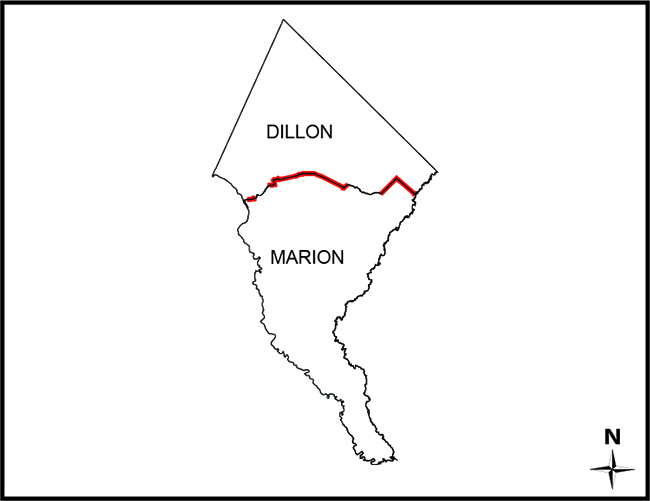
SC Code of Law: http://www.scstatehouse.gov/code/t04c003.php
SECTION 4-3-180. Dillon County.
“...the bridge on the river road to a stake X 111 N.; thence N. 75° 56' E. 4,395 feet to a stake X 111 N., at the intersection of Gum Swamp and Cud Swamp; thence up the run of Cud Swamp to the public road leading from L. D. Haselden's to Sellers, to a stake near bridge; thence N. 82° 47' E. 3,061 feet along said road to the town limits of Seller's to a stake; thence N. 10° 26' W. 3,496.5 feet to a stake X; thence N. 87° 43' E. 2,100 feet to a stake X; thence N. 53° 22' E. 1,335 feet to a stake X; thence S. 56° 32' E. 1,107 feet to a stake X; thence N. 82° 30' E. 11,801 feet to a stake; thence N. 69° 40' E. 5,678 feet to an iron stake west side of the Marion and Latta public road near the property now or formerly owned by David Watson; thence N. 88° 30' E. 2,305 feet to an iron stake of the public highway leading from Latta towards Marion, South Carolina, on the old Bryant place, the said roads being the ones heretofore referred to in the original petition setting forth the boundary lines of the proposed new county; thence S. 89° 10' E. 6,940 feet to a stake X; thence S. 68° 72' E. 4,920 feet to a stake X; thence S. 60° 10' E. 20,545 feet to a stake X at east side of railroad; thence N. 51° 37' E. 4,242 feet to its intersection with Buck Swamp; thence down the run of Buck Swamp with its various courses and distances to its junction with Little Pee Dee River; thence a straight line N. 48° 40' E. 17,300 feet to a stake X 111 N.; thence a straight line S. 44° 48' E. 18,924 feet to a cypress tree X 3 N. at the junction of Ash Pole Swamp and Lumber River...”
SECTION 4-3-380. Marion County.
“...on the north by Dillon County...”
- Final Plat of Survey Signed 11/04/2022 by PLS No. 26946 David K. Ballard
- Map of land owned by J. Evans Goodyear, by George W. Smith, dated Apr. 24 1957 and recorded in the office of the Register of Deeds for Dillon County in Plat Book 18, Page 201.
- Survey of Ben Page Land Sellers South Carolina Marion and Dillon County, by Phillip B. Culbreth dated April 1996. Recorded in the office of Register of Deeds for Dillon county Plat Book 27, Page 78.
- Survey for Andrew Rewis of property on Sand Clay Road off US HWY 501, By William E. Hayes, dated Aug. 14, 2014. Recorded in the office of Register of Deeds for Dillon county Plat Book 46, Page 52.
- Plat of a tract of land owned by Annie Grace Sellers Gaddy, by C.O. Epps, dated February 17, 1956 and recorded in Dillon County in Plat Book 6, Page 145.
- Map of land owned by J. Larry Faulkenberry & Almond Forest Products, Inc., by Daniel Riddick & Associates, Inc. dated July 10, 1992 and recorded in the office of ROD for Dillon County Plat Book 16, Page 46 and Marion County ROD County Plat Book 26, Page 9
- Plan and Profile of Proposed State Highway Marion County docket 34.282, Roads S-83, S-195 & S-196 Streets in Sellers 1955. Approved by the State Highway Engineer, February 26, 1958.
- Surveyed by Theod. C. Hamby and E.N. Beaty, dated March of 1909; filed with the South Carolina Department of Archives and History
- Surveyed October & November 1898 by S. Redd Stoney; revised August 1901 by R.L. Freeman; revised July and August of 1906 by J.T Wardlaw; being copied from the original by J.T. Wardlaw December 27, 1906. Filed with The South Carolina Department of Archive
- Map of property surveyed for Gillie Wilson, Dillon and Marion Counties, SC. By Johnson & Roberts, CE’s dated Aug. 1962 Recorded in the office of Register of Deeds for Marion county Plat Book 11, Page 149
- A subdivision survey of 587.16 acres near the Ashpole Swamp on the Lumber River for the Jesse Floyd Estate. By Robert Bryan Pittman, PLS, dated Aug. 31, 2017. Recorded in the office of Register of Deeds for Marion county Plat Book 416, Page 3.
- by C.O. Epps, dated May 15, 1970 and recorded in Dillon county in Plat Book 11, Page 39.
Disclaimer
The Revenue and Fiscal Affairs Office is providing access to these materials for educational and research purposes and is not aware of any U.S. copyright protection (see Title 17 of the United States Code) or any other restrictions in the provided materials.
Note that the written permission of the copyright owners and/or other rights holders (such as publicity and/or privacy rights) is required for distribution, reproduction, or other use of protected items beyond that allowed by fair use or other statutory exemptions. Responsibility for making an independent legal assessment of an item and securing any necessary permissions ultimately rests with persons desiring to use the item.