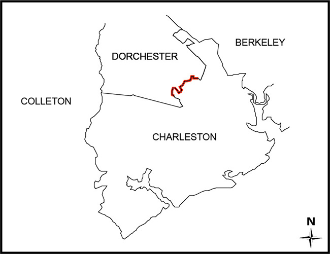
SECTION 4-3-100. Charleston County.
“…thence northward following the center line of Rantowles Creek to its intersection with the Dorchester County line; thence following said line to its intersection with the property of Charles H. P. Duell (Middleton Gardens); thence following the eastern boundary of the property of Charles H. P. Duell (Middleton Gardens) to the ordinary high-water line on the eastern bank of the Ashley River…”
SECTION 4-3-320. Dorchester County.
“…on the southeast by Charleston County, from which it is separated by the old division line between Charleston and Colleton Counties…”
SECTION 4-3-231. Dorchester County; additional area of Charleston County transferred to Dorchester County.
The following described portion of Charleston County is hereby transferred and annexed to Dorchester County:
All that tract of land now situate and lying in Charleston County, being a portion of property formerly known as "Middleton Tract" and more commonly known as "Middleton Place", said tract containing 1,085 acres more or less and constituting the southernmost portion of Middleton Place to the west of South Carolina Highway 61 and more particularly shown on the tax maps of Charleston County as T.M.S. Number 301-001 and also shown on a plat recorded in the office of the Clerk of Court for Dorchester County in Plat Book 21, at page 42, and in the R.M.C. office for Charleston County in Plat Book AC, at page 144; and
All that tract of land now situate and lying in Charleston County, being a portion of property formerly known as "Middleton Tract" and more commonly known as "Middleton Place", said tract containing 130 acres, more or less, of highland and 49 acres, more or less, of marshland, and constituting the southernmost portion of Middleton Place to the east of South Carolina Highway 61 and more particularly shown on the tax maps of Charleston County as T.M.S. Number 364-011 and also shown on a plat recorded in the office of the Clerk of Court for Dorchester County in Plat Book 21, at page 42 and in the R.M.C. office for Charleston County in Plat Book AC, at page 144.
ACT 267 of 1985:
“Portion of Charleston County transferred to Dorchester County
Section 1. The following described portion of Charleston County is transferred and annexed to Dorchester County:
All that tract of land containing 50.61 acres and bounded on the west and north by property of Charles H. P. Duell, on the east by property of W. O. Hanahan, and on the south by South Carolina Highway #61, all as shown a plat entitled ‘A Plat of a Tract owned by Charles H. P. Duell Showing Present and Proposed Dorchester-Charleston County line, St. Andrew’s Parish, Charleston, South Carolina’ dated February 11, 1984, by William C. Boineau, Thomas G. McLeod, and Robert J. Sample”
- Certified Plat of Survey: Charleston County Plat Book L17 pages 0025 - 0032; Dorchester County Plat Book M, page 104
- 1900 Map of Dorchester County - § Knight, J. Hamilton. Map of Dorchester County, South Carolina: made and created by an Act of the Legislature of So. Ca. Feb'y 25th 1897, from portions of Colleton and Berkeley counties. [South Carolina?: Publisher not ide
- Plat from 1977 Annexation - § Hilton, H. Exo. Plat of 1261.79 Acres Portion of Middleton Place Located in St. Andrews Parish, Charleston County, S.C. to be Transferred to Dorchester County, S.C. dated Sept. 1976. Map. Provided by the South Carolina Depart
- Plat from 1985 Annexation - § Boineau, William C.; McCleod, Thomas G.; Sample, Robert J. A Plat of a Tract Owned by Charles H.P. Duell: Showing Present and Proposed Dorchester-Charleston County Line, dated February 11, 1984. Map. Provided by the South Car
Disclaimer
The Revenue and Fiscal Affairs Office is providing access to these materials for educational and research purposes and is not aware of any U.S. copyright protection (see Title 17 of the United States Code) or any other restrictions in the provided materials.
Note that the written permission of the copyright owners and/or other rights holders (such as publicity and/or privacy rights) is required for distribution, reproduction, or other use of protected items beyond that allowed by fair use or other statutory exemptions. Responsibility for making an independent legal assessment of an item and securing any necessary permissions ultimately rests with persons desiring to use the item.