SC Code of Law: (http://www.scstatehouse.gov/code/t04c003.php)
SECTION 4-3-200. Dorchester County.
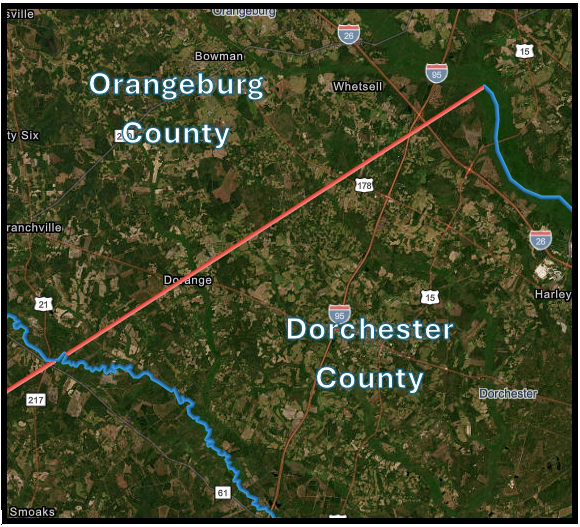
Dorchester County is composed of … all that portion formerly of Berkeley County included within the following lines, to wit: from the intersection of the county line between Colleton and Berkeley Counties with the run of Four Holes Creek a straight line to a point upon Saw Mill Branch one mile northeast of the Southern Railway; thence along said branch to the former Colleton County line, and thence back to the starting point along the former line of division between Colleton and Berkeley Counties. And is bounded northeast by Berkeley County, from which it is separated by the Four Holes Swamp from the intersection of said swamp with the old district line (drawn from Nelson's Ferry, on the Santee River, to Matthews' Bluff, on Savannah River) to the intersection of the run of said swamp with the old county line between Colleton and Berkeley Counties; and by a straight line running thence to a point upon Saw Mill Branch one mile northeast of the South Carolina and Georgia Railroad, … and on the northwest and northeast by Orangeburg County, from which it is separated by said last-mentioned district line.
HISTORY: 1962 Code SECTION 14-68; 1952 Code SECTION 14-68; 1942 Code SECTION 2993; 1932 Code SECTION 2993; Civ. C. '22 SECTION 685; Civ. C. '12 SECTION 604; Civ. C. '02 SECTION 544; 1897 (22) 595.
SECTION 4-3-430. Orangeburg County.
Orangeburg County is bounded as follows: … on the southwest by Berkeley and Colleton Counties from which it is divided by a line drawn S. 52° W. from Nelson's Ferry, on the Santee River, to Matthews' Bluff, on the Savannah River; on the southwest by Barnwell and Bamberg Counties from which it is separated by the South Edisto River; on the northwest by Aiken and Lexington Counties from which it is divided by a direct line drawn from A. J. Weathersbee's old mill, on the line between Barnwell and Aiken Counties, to the point where the Cedar Pond Branch empties into the North Fork of the Edisto, and by another direct line, drawn from said point where the Cedar Pond Branch empties into the North Fork of the Edisto, to the headwaters of the main branch of Beaver Creek; thence down said creek to the line of Calhoun County; thence along said line to the Santee River; …
HISTORY: 1962 Code SECTION 14-88; 1952 Code SECTION 14-88; 1942 Code SECTION 3013; 1932 Code SECTION 3013; Civ. C. '22 SECTION 705; Civ. C. '12 SECTION 622; Civ. C. '02 SECTION 561; G. S. 430; R. S. 489; (5) 407; (7) 199, 261, 284; 1870 (14) 695.
- List of historical documents used in the re-establishment of the Dorchester Orangeburg County Boundary
Disclaimer
The Revenue and Fiscal Affairs Office is providing access to these materials for educational and research purposes and is not aware of any U.S. copyright protection (see Title 17 of the United States Code) or any other restrictions in the provided materials.
Note that the written permission of the copyright owners and/or other rights holders (such as publicity and/or privacy rights) is required for distribution, reproduction, or other use of protected items beyond that allowed by fair use or other statutory exemptions. Responsibility for making an independent legal assessment of an item and securing any necessary permissions ultimately rests with persons desiring to use the item.