SC Code of Law: (http://www.scstatehouse.gov/code/t04c003.php)
SECTION 4-3-250. Fairfield County
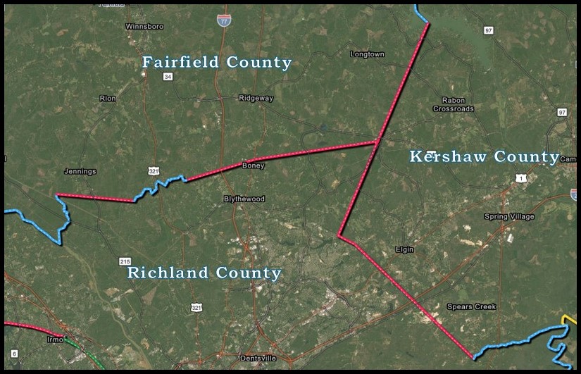
“on the south by Richland County from which it is separated by Little River from its mouth up to a point about one-half mile above the plantation now or formerly owned by Mr. Shaffer (one mile above the mouth of Shaffer's Creek) and the line running from thence in a direct course to new corner on the Fairfield-Richland line where it crosses the median line of Cedar Creek; thence up the median line of Cedar Creek with its various sources to Simmons' Creek; thence up the median line of Simmons' Creek to a point marked X 3 N. on the bank of Simmons' Fork on Cedar Creek; thence N. 72° 10' E. 23,800 feet to a stake on the Ridgeway-Blythewood Road; thence N. 82° 20' E. 41,338 feet to a stake on the dividing line between Fairfield and Kershaw Counties; on the east by the counties of Kershaw and Lancaster from which it is separated by a line drawn from the last-named point in a northeasterly direction to Wateree River where Cornell's Creek enters it;”
SECTION 4-3-330. Kershaw County
“…. thence in a southwest direction along the Sumter County line to the Wateree River; on the southwest by Richland County, from which it is divided by a line beginning at the Wateree River, opposite to the last-mentioned point, and running S. 66° W. or by Raglin's Creek to Speer's Creek; thence up Raglin's Creek to its head; thence by a straight line N. 40.75° W. 10 miles 17 chains; thence N. 56.5° W. 1 mile 14 chains to a point over Rice Creek on Peay's plantation, nearly half a mile above the fork of Twenty-five Mile Creek; on the west by Fairfield County, from which it is separated by a line drawn from the last-mentioned point N. 18.25° E. 23 miles 14 chains or until it intersects the Wateree River and up said river 1/2 mile above Peay's Ferry….”
SECTION 4-3-460. Richland County
“Richland County is bounded on the north by Fairfield County, from which it is separated by new boundary lines set forth and specifically described in the location and boundary of Fairfield County; on the east by Kershaw County and Sumter County from which it is separated by the Wateree River…..”
- Inhabitants of Richland County, petition asking that the original boundaries of Richland County may once more be established, and the courthouse for the county be permanently fixed at the plantation of William Meyer. 4 pages.SC Department of Archives and History. Series: S165015.
- Resolution Appointing Commissioners To Ascertain The Boundary Lines Between Several Counties. 2 pages. SC Department of Archives and History. Series: S165018.
- Inhabitants of Richland County residing near the Fairfield County line, petition protesting a chang in the boundary between the counties. 2 pages. SC Department of Archives and History. Series: S165015.
- Marking the line of division between the head of Round Top to the Little River. SC Department of Archives and History. Series: S165018.
- Fairfield District, South Carolina / surveyed by John Allen Tharp, 1820; engd. by H.S. Tanner & Assistants; improved by Robert Mills’ atlas, 1825. Library of Congress. Permalink: https://lccn.loc.gov/2013593136.
- Kershaw District, South Carolina / surveyed by J. Boykin, 1820; improved for Mill's Atlas, 1825. Library of Congress. Permalink: https://lccn.loc.gov/2007627626
- Richland District, South Carolina; surveyed by Marmaduke Coates, 1820; improved by Robert Mills’ atlas, 1825. Library of Congress. Permalink: https://lccn.loc.gov/2007627903.
- Surveyed By E. Parker. Date: 9/4/1850. South Carolina State Department of Archives and History. State Plat Books (Columbia Series) (S213192).
- Surveyed By E. Parker, Originally Granted To Oquinn And English. Date: 10/29/1850. South Carolina State Department of Archives and History. State Plat Books (Columbia Series) (S213192).
- Surveyed By H. Edmonds. Date: 7/22/1857. South Carolina State Department of Archives and History. State Plat Books (Columbia Series) (S213192).
- Map of Fairfield Co. South Carolina, Surveyed by Wm. B. & B. E. Elkin, 1875. Entered according to Act of Congress in the year 1875 by Balis Earl Elkin & Wm. Barnes Elkin in the Office of Librarian of Congress at Washington.Scale 2 miles per inc. 896 square miles. Library of Congress. Permalink: https://lccn.loc.gov/2013593122.
- Geological & agricultural map, compiled from railroad, coast & state surveys by E.M. Stoeber. University of South Carolina Caroliniana Library Map Collection: https://digital.library.sc.edu/collections/south-caroliniana-library-map-collection/.
- M.L. Brasswell, Surveyor. Library of Congress. Permalink: https://lccn.loc.gov/2013593128.
- Map of Portion of Fairfield Co. Containing 47.07 Sq. Mi. Proposed Annex to Richland Co. Surveyed Dec. 1910 by Alfred T. Jones & C. W. Wannamaker. South Carolina Archives Map Collection, S6608No32.
- Transferring Blythewood and Bear Creek, as discussed in later 1933 article in The State. Statutes at Large of the State of South Carolina, 1913.
- Showing boundary south of Twenty Mile Creek. Kershaw County Registrar of Deeds, Plat Book 2 Page 31.
- Showing Kershaw-Richland boundary near Spears Creek. Kershaw County Register of Deeds, Plat Book 7, Page 14.
- Historic section where Col. Richard Kirkland settled 200 years ago got its name form Bears killed near it - Supervisor Hinnant trying to give them good roads all the way to Columbia - Trip through it described.By F. H. McMaster. The State Newspaper. September, 24, 1933, page 6.
- Showing Kershaw-Richland boundary at meeting of Raglins Gut and Wateree River. Kershaw County Register of Deeds, Plat Book 36, Page 2705.
- Showing Kershaw-Richland boundary west of Spears Creek at Raglins Gut. Kershaw County Register of Deeds, Plat Book 34, Page 1526.
- By J. W. Simmons, dated 1933. Recopy dated 4/20/1959. South Carolina Geodetic Survey archives.
- 1971 United States Geologic Survey quad map of Elgin SC showing southwestern Kershaw county and northeast Richland county.
- 1938 USGS quad map showing Kershaw south of Camden and Richland boundary at Raglin’s Gut.
- 1938 USGS quad map of Killian showing northeast Richland and southwest Kershaw counties.
- 1953 USGS quad map of Kershaw-Richland boundary north and northeast of Fort Jackson.
- 1971 USGS quad map of Longtown vicinity showing Fairfield-Kershaw county line from tricorner to Wateree River.
- 1953 USGS quad map of Richland county above Fort Jackson showing boundary of Kershaw and Richland counties.
Disclaimer
The Revenue and Fiscal Affairs Office is providing access to these materials for educational and research purposes and is not aware of any U.S. copyright protection (see Title 17 of the United States Code) or any other restrictions in the provided materials.
Note that the written permission of the copyright owners and/or other rights holders (such as publicity and/or privacy rights) is required for distribution, reproduction, or other use of protected items beyond that allowed by fair use or other statutory exemptions. Responsibility for making an independent legal assessment of an item and securing any necessary permissions ultimately rests with persons desiring to use the item.