

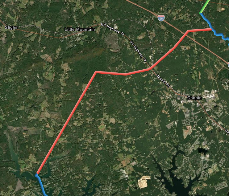
Re-Establishment Survey Files
-
Folder Containing .dbf .idx .prj .shp .shx Files
-
Plat of survey of the Lexington Newberry County Boundary (pending certification)
S.C. Code of Law
SC Code of Law: (http://www.scstatehouse.gov/code/t04c003.php)
SECTION 4-3-370. Lexington County.
....Newberry County, from which it is separated by a line beginning at a point in Broad River, on the Fairfield-Lexington County line, about .25 of a mile below Peak, and running thence S. 40° W. to a point on the west bank of Broad River; thence S. 40° W. 1956 feet to an oak; thence S. 46° 40' W. 2410 feet to a stone on the public road; thence S. 41° W. 1143 feet to a stake; thence S. 32° 30' W. 9568 feet to a stake on a branch; thence down the run of the branch to a stake; thence S. 45° W. 575 feet to a stake; thence N. 86° 30' W. 3782 feet to a pine; thence S. 26° 30' W. 3650 feet to a stake; thence S. 53° 30' W. 4990 feet to a point on the Columbia, Newberry and Laurens Railroad; thence S. 73° 30' W. 2613 feet to a maple in a branch; thence S. 68° 30' W. 2180 feet to a stake near a negro church; thence N. 77° 30' W. 5577 feet to a stake just west of the public road, near Little Mountain; thence S. 28° W. 20850 feet to Camping Creek, near the mouth of Stevens Creek; thence up the run of Camping Creek to the old Newberry-Lexington County line; thence southwesterly with the old Newberry-Lexington County line to Saluda County on Broad River. Less however, that territory transferred to Richland County by act approved March 11 1922, to wit: all that certain piece of land containing 8900 acres, or 14 square miles, situate in the northeastern part of Lexington County on the Broad River, and being bounded and delineated as follows, to wit: beginning at a point on said Broad River, and running S. 41° W. 82.51 chains to a stake, thence turning and running S. 32.5° W. 160.65 chains to a stake, thence running along a creek which empties into Wateree Creek 42.24 chains to a stake, thence running to the point where said creek joins Wateree Creek 71.51 chains, thence running along said Wateree Creek 94 chains, thence turning and running S. 23° E. 142.50 chains to a point in Slice Creek known as Rocky Ford, thence turning and running northerly along Slice Creek 164 chains, thence turning and running easterly along Wateree Creek 305.00 chains to the point of entrance of Wateree Creek and Broad River, thence turning and running in a northwesterly direction along Broad River 410 chains, said piece of land being bounded on the west by Newberry County, on the south and southwest by Lexington County, on the south by Richland County, and on the east and north by the Broad River, being more particularly known as the plat of said property, completed on November 25 1921, by W. A. Counts and J. C. Wessinger, surveyors, said plat being filed in the office of the Secretary of State. And less that territory transferred to Newberry County by act approved May 12 1953, to wit: all of that certain territory or portion of Lexington County embraced within the following lines and boundaries, to wit: beginning at a point of the intersection of Lexington County-Saluda County-Newberry County lines at Saluda River; thence N. 22° 30' E. 17710 feet to Camping Creek; thence in a general southeastern direction along Camping Creek to confluence of Saluda River; thence in a northwesterly direction along Saluda River to point of beginning, being more particularly lined and described on a plat of said territory by the Columbia Engineering Company, completed November 1 1952, said plat being filed in the office of the Secretary of State.
HISTORY: 1962 Code SECTION 14-82; 1952 Code SECTION 14-82; 1942 Code SECTION 3007; 1932 Code SECTION 3007; Civ. C. '22 SECTION 699; Civ. C. '12 SECTION 617; Civ. C. '02 SECTION 556; G. S. 125; R. S. 484; (5) 478, 506; (6) 463, 664; (7) 248; 1870 (14) 695; 1896 (22) 249; 1901 (23) 662; 1912 (27) 821; 1913 (28) 107; 1920 (31) 976; 1922 (32) 977; 1953 (48) 416.
SECTION 4-3-410. Newberry County.
Newberry County is bounded as follows: on the northwest by Laurens County from which it is separated by line beginning at Island Ford on Saluda River and running thence along the old road to O'Dell's Ford on Enoree River; on the north by a line commencing at O'Dell's Ford on Enoree River and running thence down Enoree River to Anderson's Ford; thence along the road to Hill's Ferry on Tyger River; thence down the same to the mouth; thence down Broad River to a point on the Fairfield-Lexington County line about one fourth of a mile below Peak, and running thence S. 40° W. to a point on the west bank of Broad River; thence S. 40° W. 1956 feet to an oak; thence S. 46° 40' W. 2410 feet to a stone in the public road; thence S. 41° W. 1143 feet to a stake; thence S. 32° 30' W. 95.68 feet to a stake on a branch; thence down the run of the branch to a stake; thence S. 55° W. 575 feet to a stake; thence N. 86° 30' W. 3782 feet to a pine; thence S. 26° 30' W. 3650 feet to a stake; thence S. 50° 30' W. 4940 feet to a point on the Columbia, Newberry and Laurens Railroad; thence S. 73° 30' W. 2613 feet to a maple in a branch; thence S. 68° 30' W. 2180 feet to a stake near a negro church; thence N. 77° 30' W. 5577 feet to a stake, just west of the public road near Little Mountain; thence S. 28° W. 2850 feet to Camping Creek near the mouth of Stevens' Creek; thence up the run of Camping Creek to the old Newberry-Lexington County line; thence with the old Lexington-Newberry County line to the Saluda River; and on the southwest by the Saluda River, which separates it from Saluda and Greenwood Counties. To the above-described area of Newberry County is to be added all that territory transferred from Lexington County by act approved May 12 1953, to wit: all of that certain territory or portion of Lexington County embraced within the following lines and boundaries, to wit: beginning at a point of the intersection of Lexington County-Saluda County-Newberry County lines at Saluda River; thence N. 22° 30' E. 17710 feet to Camping Creek; thence in a general southeastern direction along Camping Creek to confluence of Saluda River; thence in a northwesterly direction along Saluda River to point of beginning, being more particularly lined and described on a plat of said territory by the Columbia Engineering Company, completed November 1 1952, said plat being filed in the office of the Secretary of State.
HISTORY: 1962 Code SECTION 14-86; 1952 Code SECTION 14-86; 1942 Code SECTION 3011; 1932 Code SECTION 3011; Civ. C. '22 SECTION 703; Civ. C. '12 SECTION 620; Civ. C. '02 SECTION 559; G. S. 428; R. S. 487; (4) 661; (7) 199, 248, 262, 284; 1901 (23) 662; 1920 (31) 976; 1953 (48) 416.